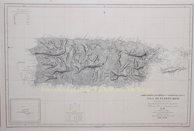
Porto Rico 1842
Miguel Moreno
€ 975
Inter-Antiquariaat Mefferdt & De Jonge
- Sobre arteRARE SPANISH SEA CHART OF PUERTO RICO “Carta Particular Esférica y Corográfica de la Isla de Puerto-Rico y las adyacentes que á la misma pertenecen, Vieques, Culebra, Caja de Muertos, Mona, Monito y Descecheo...” Rare separately published chart of Puerto Rico, drawn by Miguel Moreno and engraved by C. Noguera with lettering by M. Giraldos. Published by the Spanish Hydrographical Office in Madrid, in 1842. Size (plate mark): 62 x 93 cm. This chart of Puerto Rico depicts the topography of the island in fine detail. The island is divided into seven districts, which are identified at top left. Along the coasts, several ports, ravines, bays, river mouths, and more are located. The chart extends to show nearby island-municipalities Vieques and Culebra. Off shore shoals are shown, along with soundings, anchorages and other sailing details. An inset at bottom left provides a simple depiction of Isla de Mona (located off the west coast of Puerto Rico). The island's first lighthouses are market with a hint of colour. A key at the bottom indicates the symbols for towns and cities of various sizes as well as different soil types. The Dirección de Hidrografía, or the Directorate of Hydrographic Works, was established in 1797. Its roots were in the Casa de Contratación, founded in 1503 in Sevilla, which housed all the charts of the Spanish Empire and oversaw the creation and maintenance of the padrón real, the official master chart. The Casa, now in Cadiz, was shuttered in 1790, but Spain still needed a hydrographic body. In response, the Dirección was created in 1797. One of its first projects was the publication of charts from the Malaspina Expedition (1789-1794). The Dirección oversaw not only publication, but also surveying. The Dirección was abolished in the early twentieth century, when their work was distributed to other organisations. Price: Euro 975,-
Você está interessado em comprar esta obra de arte?
Artwork details
Categoria
Related artworks
- 1 - 4 / 24
- 1 - 4 / 12

