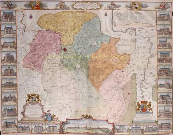
Arnhem 1649
Joan Blaeu
€ 750
Inter-Antiquariaat Mefferdt & De Jonge
- About the artwork
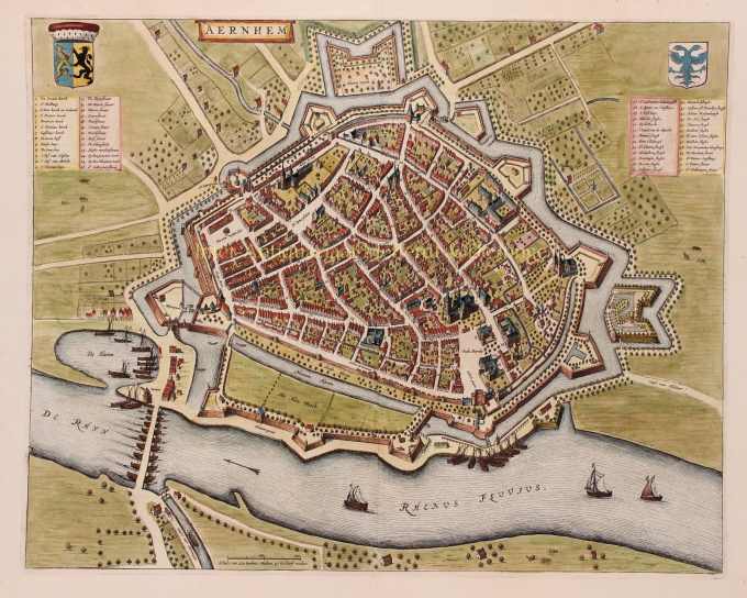
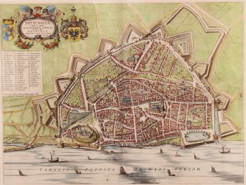
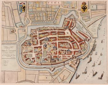
PLATTEGROND OF 17E-EEU ARNHEM "Aernhem", copper engraving by Joan Blaeu, as part of his "Toonneel der Steden", published in 1649 in Amsterdam. Later hand-coloured. Verso: Latin text. Sizes: 41 x 52,5 cm. The map was not drawn by Joan Blaeu, but by the cartographer Nicolaes van Geelkercken in 1639. Van Geelkercken received the commission for this from the Arnhem city council in 1638. The map thus reflects the situation around 1639. Van Geelkercken's design is not only found in this edition by Blaeu, but the printers Johannes Janssonius and Frederik de Wit also published variations on the map. Blaeu describes the city as follows: Arnhem is the capital of the Veluwe and seat of the highest court of the Duchy of Gelre. The city is "mighty, glorious, strong and rich in citizens". The Rhine flows along the city wall and the air is good because of the surrounding forests. In the surrounding area, the citizens have pleasant courtyards and gardens. On the side of the Veluwe, in the direction of Maastricht, there is a hill outside the city, "from the welcke sich a lustige aenschouwing over de naeste landen van de Betuwe vert vert vert". North of the town are hills and valleys planted with woods and heathland, where various kinds of wild animals are hunted. There is also the Wildhaen, once the hunting ground of the dukes, now "very useful for a walk for the citizens". To the south of the town, on the other side of the Rhine, are the beautiful fields of the Betuwe, where many oats, barley, peas, beans and other grain crops grow. Against "the violence from outside" the city has five "as strong as a castle" gates (four are made of stone). Of these, St. John's Gate was built in 1537 by Charles of Gelre, who feared the arrival of Charles V. Blaeu writes about the nature of the citizens that they are "courteous and lovers of science, and many live there from noble families". They are also heroic. Think of the city of Neuss that was helped by the citizens of Arnhemm during the siege by Charles the Bold. They also provided help during the terrible fire of Harderwijk in 1503. The city has a chapter of canons [in the St. Walburgis church], a Franciscan monastery [Broeren church on the map] and an Agnietenklooster [which passed into the hands of the St. Catharina Gasthuis in 1636]. The Commanderij van Sint-Jan is home to the Hospitaller knights, who used to collect a toll at the Janspoort on goods imported from the Veluwe, until this privilege was bought off by the bishop of Utrecht. In the Grote Kerk, with its beautiful tower, Duke Charles of Gelre is buried "in the inner court, of carved marble". See here for a nice animation of 17th century Arnhem. Price: Euro 750,-
- About the artist
Joan Blaeu (1596-1673), was born on the 23rd of September in 1596 in Alkmaar.
He was a Dutch cartographer born in Alkmaar. He followed the footsteps of his father, cartographer Willem Blaeu.
In 1620 he became a doctor of law but he joined the work of his father. In 1635 they published the Atlas Novus (full title: Theatrum orbis terrarum, sive, Atlas novus) in two volumes. Joan and his brother Cornelius took over the studio after their father died in 1638. Joan became the official cartographer of the Dutch East India Company.
Blaeu's world map, Nova et Accuratissima Terrarum Orbis Tabula, incorporating the discoveries of Abel Tasman, was published in 1648. This map was revolutionary in that it "depicts the solar system according to the heliocentric theories of Nicolaus Copernicus, which show the earth revolving around the sun.... Although Copernicus's groundbreaking book On the Revolutions of the Spheres had been first printed in 1543, just over a century earlier, Blaeu was the first mapmaker to incorporate this revolutionary heliocentric theory into a map of the world."
Blaeu's map was copied for the map of the world set into the pavement of the Groote Burger-Zaal of the new Amsterdam Town Hall, designed by the Dutch architect Jacob van Campen (now the Amsterdam Royal Palace), in 1655.
Blaeu's Hollandia Nova was also depicted in his Archipelagus Orientalis sive Asiaticus published in 1659 in the Kurfürsten Atlas (Atlas of the Great Elector). and used by Melchisédech Thévenot to produce his map, Hollandia Nova—Terre Australe (1664).
As "Jean Blaeu", he also published the 12 volume "Le Grand Atlas, ou Cosmographie blaviane, en laquelle est exactement descritte la terre, la mer, et le ciel". One edition is dated 1663. That was folio (540 x 340 mm), and contained 593 engraved maps and plates. In March 2015, a copy was on sale for £750,000.
Around 1649 Joan Blaeu published a collection of Dutch city maps named Toonneel der Steeden (Views of Cities). In 1651 he was voted into the Amsterdam council. In 1654 Joan published the first atlas of Scotland, devised by Timothy Pont. In 1662 he reissued the Atlas Novus, also known as Atlas Maior, in 11 volumes, and one for oceans.
A cosmology was planned as their next project, but a fire destroyed the studio completely in 1672.
Joan Blaeu died in Amsterdam the following year, 1673. He was buried in the Westerkerk at Amsterdam.
Are you interested in buying this artwork?
Artwork details
Related artworks
- 1 - 4 / 12
- 1 - 4 / 24
- 1 - 4 / 12

