Arnhem 1649
Joan Blaeu
€ 750
Inter-Antiquariaat Mefferdt & De Jonge
- A proposito di opere d'arte
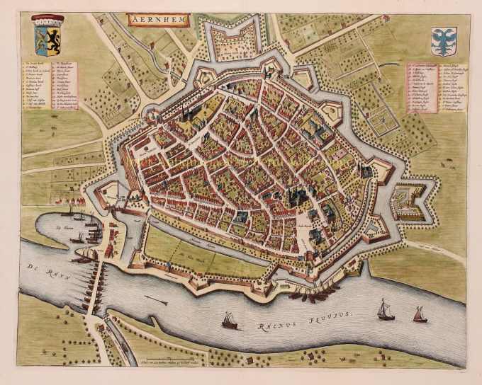
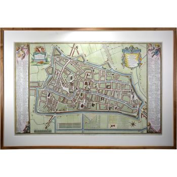
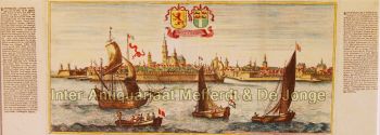
PLATTEGROND OF 17E-EEU ARNHEM "Aernhem", copper engraving by Joan Blaeu, as part of his "Toonneel der Steden", published in 1649 in Amsterdam. Later hand-coloured. Verso: Latin text. Sizes: 41 x 52,5 cm. The map was not drawn by Joan Blaeu, but by the cartographer Nicolaes van Geelkercken in 1639. Van Geelkercken received the commission for this from the Arnhem city council in 1638. The map thus reflects the situation around 1639. Van Geelkercken's design is not only found in this edition by Blaeu, but the printers Johannes Janssonius and Frederik de Wit also published variations on the map. Blaeu describes the city as follows: Arnhem is the capital of the Veluwe and seat of the highest court of the Duchy of Gelre. The city is "mighty, glorious, strong and rich in citizens". The Rhine flows along the city wall and the air is good because of the surrounding forests. In the surrounding area, the citizens have pleasant courtyards and gardens. On the side of the Veluwe, in the direction of Maastricht, there is a hill outside the city, "from the welcke sich a lustige aenschouwing over de naeste landen van de Betuwe vert vert vert". North of the town are hills and valleys planted with woods and heathland, where various kinds of wild animals are hunted. There is also the Wildhaen, once the hunting ground of the dukes, now "very useful for a walk for the citizens". To the south of the town, on the other side of the Rhine, are the beautiful fields of the Betuwe, where many oats, barley, peas, beans and other grain crops grow. Against "the violence from outside" the city has five "as strong as a castle" gates (four are made of stone). Of these, St. John's Gate was built in 1537 by Charles of Gelre, who feared the arrival of Charles V. Blaeu writes about the nature of the citizens that they are "courteous and lovers of science, and many live there from noble families". They are also heroic. Think of the city of Neuss that was helped by the citizens of Arnhemm during the siege by Charles the Bold. They also provided help during the terrible fire of Harderwijk in 1503. The city has a chapter of canons [in the St. Walburgis church], a Franciscan monastery [Broeren church on the map] and an Agnietenklooster [which passed into the hands of the St. Catharina Gasthuis in 1636]. The Commanderij van Sint-Jan is home to the Hospitaller knights, who used to collect a toll at the Janspoort on goods imported from the Veluwe, until this privilege was bought off by the bishop of Utrecht. In the Grote Kerk, with its beautiful tower, Duke Charles of Gelre is buried "in the inner court, of carved marble". See here for a nice animation of 17th century Arnhem. Price: Euro 750,-
- A proposito di opere artista
Joan Blaeu (1596-1673), nacque il 23 settembre 1596 ad Alkmaar.
Era un cartografo olandese nato ad Alkmaar. Ha seguito le orme di suo padre, il cartografo Willem Blaeu.
Nel 1620 divenne dottore in legge ma si unì al lavoro del padre. Nel 1635 pubblicarono l'Atlas Novus (titolo completo: Theatrum orbis terrarum, sive, Atlas novus) in due volumi. Joan e suo fratello Cornelius rilevarono lo studio dopo la morte del padre nel 1638. Joan divenne il cartografo ufficiale della Compagnia Olandese delle Indie Orientali.
La mappa del mondo di Blaeu, Nova et Accuratissima Terrarum Orbis Tabula, che incorpora le scoperte di Abel Tasman, fu pubblicata nel 1648. Questa mappa era rivoluzionaria in quanto "raffigura il sistema solare secondo le teorie eliocentriche di Niccolò Copernico, che mostrano la terra che ruota attorno il sole... Sebbene l'innovativo libro di Copernico Sulle rivoluzioni delle sfere fosse stato stampato per la prima volta nel 1543, poco più di un secolo prima, Blaeu fu il primo cartografo a incorporare questa rivoluzionaria teoria eliocentrica in una mappa del mondo."
La mappa di Blaeu è stata copiata per la mappa del mondo ambientata nel pavimento del Groote Burger-Zaal del nuovo municipio di Amsterdam, progettato dall'architetto olandese Jacob van Campen (ora il Palazzo Reale di Amsterdam), nel 1655.
L'Hollandia Nova di Blaeu fu raffigurata anche nel suo Archipelagus Orientalis sive Asiaticus pubblicato nel 1659 nel Kurfürsten Atlas (Atlante del Grande Elettore). e utilizzato da Melchisédech Thévenot per produrre la sua mappa, Hollandia Nova-Terre Australe (1664).
Come "Jean Blaeu", ha anche pubblicato il volume 12 "Le Grand Atlas, ou Cosmographie blaviane, en laquelle est exactement descritto la terre, la mer, et le ciel". Un'edizione è datata 1663. Era in folio (540 x 340 mm) e conteneva 593 mappe e tavole incise. Nel marzo 2015, una copia era in vendita per £ 750.000.
Intorno al 1649 Joan Blaeu pubblicò una raccolta di mappe cittadine olandesi chiamata Toonneel der Steeden (Vedute di città). Nel 1651 fu votato nel consiglio di Amsterdam. Nel 1654 Joan pubblicò il primo atlante della Scozia, ideato da Timothy Pont. Nel 1662 ristampò l'Atlas Novus, noto anche come Atlas Maior, in 11 volumi e uno per gli oceani.
Una cosmologia era prevista come progetto successivo, ma un incendio distrusse completamente lo studio nel 1672.
Joan Blaeu morì ad Amsterdam l'anno successivo, 1673. Fu sepolto nella Westerkerk ad Amsterdam.
Sei interessato ad acquistare questa opera d'arte?
Artwork details
Related artworks
- 1 - 4 / 12
Marc Chagall
Frontispiece for Windows for Jerusalem1952 - 1980
Prezzo su richiestaArthouse Marc Chagall
1 - 4 / 24- 1 - 4 / 12

