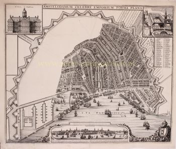
MOLTO RARA PRIMA MAPPA STAMPATA DI AMSTERDAM, UNA CITTÀ IN AUMENTO 1544
Cornelis Anthonisz Theunissen
Carta
100 ⨯ 103 cm
€ 175.000
Inter-Antiquariaat Mefferdt & De Jonge
- A proposito di opere d'arte
“De vermaerde koopstadt van Amstelredam” [The renowned trading city of Amsterdam], woodcut printed from twelve blocks, with text printed in letterpress, made in 1544 by Cornelis Anthonisz. Size (including decorative border): approx. 100.5 x 103.5 cm. In 1544, Amsterdam was part of the Habsburg Empire under Emperor Charles V. The city had only about 12,000 inhabitants, and construction was largely confined to the area within the Singel, a small part of the Amstel River, the Kloveniersburgwal, and the Geldersekade. There was no Grachtengordel ["canal belt"] as we know it today. The map shows developments in the Lastage, the area east of the Geldersekade. Here, just a stone's throw from the Oude Kerk, workers are active in shipyards and sawmills. This suggests that the city was beginning to build its trade over the water. The connection to shipping and trade, and implicitly its reliance on it, is further highlighted by the numerous ships depicted both within and beyond the wooden palisades in the IJ waterfront. Billowing sails, salutes from cannon shots, and small boats coming and going illustrate a city on the brink of becoming one of the world’s most important. To the west of the city (under clouds in the top right corner) are the market gardens that were later urbanized during the expansions of 1585-1586 and 1610-1615. Within the city walls, several buildings are visible, including the Schreierstoren, which still stands today. Also shown are several churches, the Munttoren (then part of the Regulierspoort), and the Waag on the Nieuwmarkt. Cornelis Anthonisz. is thought to have been inspired by a map of Venice, also in bird’s-eye view, created in 1500. Both maps are adorned with a mythological god; however, while the map of Venice features both Mercury and Neptune, Cornelis Anthonisz. includes only Neptune. Interestingly, this sea god on the Amsterdam map appears to be shouting, his mouth open, showing a less-than-perfect set of teeth. By choosing a high vantage point, Cornelis Anthonisz. skillfully combined detailed building depictions with an ability to show the layout of city walls, roads, river, and canals. An impressive feat, especially considering that Anthonisz. only had access to towers to view the city from a higher perspective. In his imagination, he flies above the city, peering over fences and observing city life. Midway along the Amstel, which divides the city, the Dam (with the old town hall) is clearly recognizable. Ships dock there to trade their goods. --- There are only six known editions of this map, printed between 1544 and 1664 from the same twelve woodblocks. The map’s image remained unchanged; only the typesetting in the text block was adjusted for each edition. Our example is the third edition, printed between 1545 and 1553. This woodcut is based on a map of Amsterdam that Cornelis Anthonisz. painted on wooden panels in 1538. This was actually the first map of the city ever made. Six years later, this first printed map of Amsterdam appeared. Notably, our example was supplemented (presumably in the 18th century) with a manuscript legend listing 54 places and buildings, both within and outside the city. Literature: Marc Hameleers (2013) “Kaarten van Amsterdam 1538-1865”, no. 2 A.E. d'Ailly (1934) “Catalogus van Amsterdamsche plattegronden”, no. 30 Hollstein “Dutch & Flemish Etchings, Engravings, and Woodcuts ca. 1450 – 1700”, no. 47-III Frederik Muller (1863-1882) "Nederlandsche historieplaten", no. 393-A: “an equally beautiful, accurate, important, and rare map” Price: Euro 175.000,- (incl. frame)
- A proposito di opere artista
Cornelis Anthonisz. (spesso scritto "Anthonisz.") Theunissen fu un illustre pittore, incisore e cartografo olandese nato ad Amsterdam nel 1499 e attivo nei primi anni del XVI secolo. È rinomato per i suoi contributi alla cartografia e alle rappresentazioni cittadine, in particolare le sue mappe panoramiche di Amsterdam.
Anthonisz. proveniva da una famiglia di artisti: era nipote di Jacob Cornelisz. van Oostsanen, un importante artista dell'epoca, da cui probabilmente apprese le basi della pittura e della stampa. La sua dettagliata mappa xilografica di Amsterdam del 1538, commissionata dal governo della città, è considerata una delle sue opere più significative.
Questa mappa, intitolata Vista a volo d'uccello di Amsterdam, è una delle prime rappresentazioni note della città e riflette il crescente sviluppo urbano e la vivace attività di Amsterdam nel primo periodo rinascimentale. Il livello di dettaglio nella sua mappa mostra non solo un acuto senso di abilità artistica, ma anche una comprensione avanzata della geografia e della disposizione spaziale, che erano notevoli per l'epoca.
Oltre alle sue mappe, Cornelis Anthonisz. fu anche coinvolto in vari progetti di pittura, tra cui ritratti e scene religiose, sebbene il suo lavoro cartografico rimanga la sua eredità più duratura. La sua influenza si estese alle generazioni successive di cartografi olandesi, poiché le sue opere servirono come importanti riferimenti per le mappe successive di Amsterdam e di altre regioni nei Paesi Bassi. Anthonisz. morì intorno al 1553, ma i suoi contributi alla cartografia olandese e al genere del paesaggio urbano continuano a essere celebrati nella storia dell'arte e della cartografia nei Paesi Bassi.
Sei interessato ad acquistare questa opera d'arte?
Artwork details
Related artworks
- 1 - 4 / 24
Artista Sconosciuto
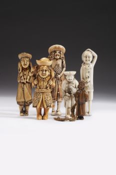
Olandesi in miniatura18th century
Prezzo su richiestaZebregs & Röell - Fine Art - Antiques
Artista Sconosciuto
A large Japanese Imari porcelain 'VOC Groningen' dish1800 - 1925
Prezzo su richiestaZebregs & Röell - Fine Art - Antiques
Artista Sconosciuto
Due ritratti di studio di Mas Marco Kartodikromo1900 - 1950
Prezzo su richiestaZebregs & Röell - Fine Art - Antiques
Artista Sconosciuto
Olandesi in miniatura (Netsuke)1700 - 1900
Prezzo su richiestaZebregs & Röell - Fine Art - Antiques
Artista Sconosciuto
A silver spoon commemorating Juff’ Margareta van Hoorn1656 - 1694
Prezzo su richiestaZebregs & Röell - Fine Art - Antiques
Artista Sconosciuto
UN RARO SADELI INDIANO COMPLETO DI LAVORO E SCRITTURA INTARSIATI1800 - 1850
Prezzo su richiestaZebregs & Röell - Fine Art - Antiques
1 - 4 / 24- 1 - 4 / 24
- 1 - 4 / 12


