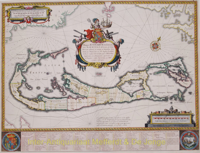
Mappa delle Bermuda 1630
Willem Janszoon Blaeu
€ 2.250
Inter-Antiquariaat Mefferdt & De Jonge
- A proposito di opere d'arteMappa Aestivarum Insularum, alias BarmudasPublished by Willem Blaeu in Amsterdam approx. 1630. Blaeu based his work on John Speed's very accurate map of 1626-1627. It shows the island divided into tribes and lots. Below the map itself appear the names of the first proprietors and the number of shares assigned to each. A splendid cartouche shows Neptune astride the Royal Arms holding a ship. The miniature map below the cartouche shows the correct proportion of the island to the coast of the mainland. Further adorned with scale cartouches, coats of arms and compass rose with a fleur-de-lys. The map is superimposed over a map of the Atlantic with the coastlines of Britain, North America and Hispanola showing the location of Bermuda. Coloured by a later hand. Size: 40,4 x 53,1 cm. Price: Euro2.250,- (excl. VAT/BTW)
- A proposito di opere artista
"Willem Janszoon Blaeu e suo figlio Joan incarnavano l'"età d'oro" della cartografia olandese. Lavorando durante il diciassettesimo secolo, Willem Blaeu disegnò una serie di mappe rivoluzionarie e pubblicò il primo atlante.
Nacque nel 1571 ad Amsterdam e lavorò inizialmente come impiegato nel commercio di aringhe di famiglia. Tuttavia, non era contento della sua occupazione e lasciò la casa nel 1594 per studiare matematica sotto Tycho Brahe, il famoso astronomo. Blaeu era un bravo studente che impressionò molto il suo tutor, e quando i suoi studi furono completati tornò ad Amsterdam e iniziò un'attività come cartografo. La sua attività fiorì e la sua reputazione crebbe. Fu il primo cartografo a produrre mappe a foglio singolo di molti paesi europei.
Nel 1605 realizzò una mappa murale del mondo, comprendente 20 fogli, ciascuno largo 8 piedi. Questa mappa era di gran lunga la più accurata del periodo e ha dato un contributo eccezionale alla conoscenza della geografia mondiale.
La sua mappa rimase la più accurata fino al 1648, quando suo figlio, Joan, che divenne anche un famoso cartografo, la aggiornò. Ma il suo risultato più importante fu la produzione del primo atlante nel 1630. Il nome Blaeu era in realtà un soprannome di famiglia che Willem assunse dopo che si era verificata confusione tra lui e il suo grande rivale Joannes Jansonius.
Sei interessato ad acquistare questa opera d'arte?
Artwork details
Related artworks
- 1 - 4 / 8
- 1 - 4 / 24
- 1 - 4 / 12

