Caraïbes, Îles du Vent 1719 - 1723
Joachim Ottens
€ 975
Inter-Antiquariaat Mefferdt & De Jonge
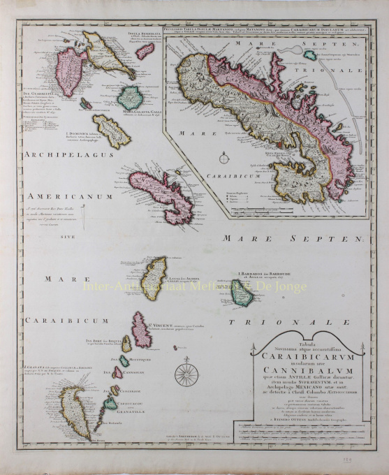
- Sur l'oeuvre d'artDETAILED MAP OF THE WINDWARD ISLANDS “Tabula novissima atque accuratissima Caraibicarum insularum sive Cannibalum : quae etiam Antillae Gallicae dicuntur, item insulae Supraventum, et in Archipelago Mexicano sitae sunt, ac detectae a Christ. Columbo Ao. MCCCCLXXXXIII” [Latest and most accurate map of the Caribbean or Cannibal Islands: also called the French Antilles, or Windward Islands, located in the Archipelago of Mexico, which were discovered by Christopher Columbus in the year 1493.] Copper engraving “after the observations of skilful sailors” made by Reinier Ottens and printed by the Window of Joachim Ottens in Amsterdam 1719-1723. With original hand colouring. Size: 58 x 48 cm. Detailed map of the Windward Islands from Guadeloupe south to Grenada, including the small islands of Mustique (Grenadines) and Ronde Island (Grenada), with a large inset map of Martinique. Grenada has been moved north and is shown west of Carriacou island, in order that it fits on the sheet. Apart from topographical information, there are some notes of historic interest. According to the map tens of thousands live on Martinique (“Matanino as the locals call it and occupied by the French since July 1635”) and its tobacco is of the best quality. La Désiderade island was discovered by Christopher Columbus in 1493 on his second journey to America. “The island of Guadeloupe, called Carukeira [The Island of Beautiful Waters] by the locals, is very fertile with rice, maize, potatoes, ginger and sugar of different qualities. It is crowded with all types of parrots.” The island of Barbados has been occupied by the English in 1627. “St. Vincent, where the Caribs live, is most populated.” Price: Euro 975,-
- Sur l'artiste
Joachim Ottens (1663 - 1719) et ses fils Renier (1698 - 1750) et Joshua (? - 1765) étaient d'éminents libraires et éditeurs de cartes hollandais.
La période de 1630 à 1700 fut « l'âge d'or » de la cartographie hollandaise. Les cartes étaient perçues comme des œuvres d'art, le travail manuel était très apprécié, la gravure était au plus haut niveau, mais du point de vue de la précision géographique, les cartes des maîtres néerlandais étaient inférieures aux cartes produites en Allemagne, en France et dans d'autres pays européens. .
Joachim, le fondateur de la firme Ottens, est né à Amsterdam et a d'abord travaillé comme graveur sur cuivre. En 1711, il fonde sa propre entreprise spécialisée dans l'édition et l'impression, vendant des livres, des cartes, des cartes postales et les illustrant.
Bien que Joachim décède quelques années plus tard, ses fils, Renier et Joshua, poursuivent avec succès l'entreprise paternelle. La contribution la plus significative à la cartographie de la famille Ottens a été les énormes atlas en plusieurs volumes qu'ils ont réalisés sur commande, comme Atlas Major. Certains numéros d'Atlas sont composés de plus de 800 cartes publiées séparément.
Êtes-vous intéressé par l'achat de cette oeuvre?
Artwork details
Related artworks
- 1 - 2 / 2
- 1 - 4 / 24
- 1 - 4 / 12

