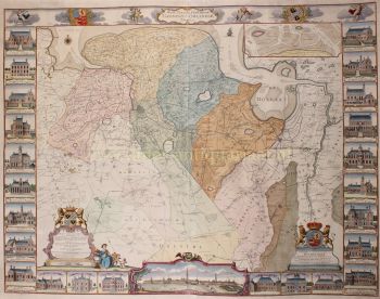
Achterhoek (contea di Zutphen) 1641
Johannes Janssonius
€ 295
Inter-Antiquariaat Mefferdt & De Jonge
- A proposito di opere d'arte
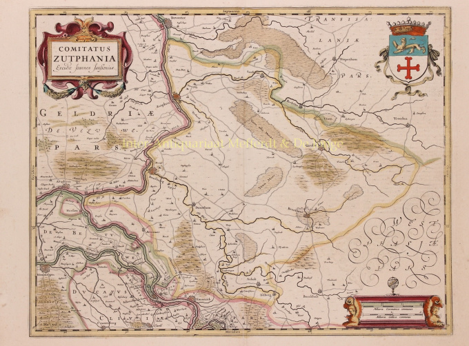
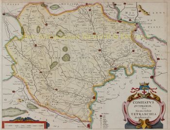
THE QUARTER OF ZUTPHEN "Comitatus Zutphania", copper engraving published by Johannes Janssonius in 1641 as part of his "Nouveau Theatre du Monde ou Nouvel Atlas". Coloured by hand at the time. Measures 46.5 x 56.4 cm. In the years 1557 to 1559 the area was mapped by Christiaan sGrooten. sGrooten's map of Gelderland was also the model for Janssonius' map of the County of Zutphen. We see the Kleef area near Huissen and Zevenaar clearly delimited. Isselburg falls within the border of the County. There are no siege works drawn around Groenlo. The area of the manor of Borculo fell under the Earldom after 1615, but is shown here as part of the Bishopric of Münster. For the city of Zutphen, the Eighty Years' War brought difficult times. In 1572, Zutphen was captured by William of Orange's brother-in-law. The Spaniards were driven out, but half a year later they took the city back and executed hundreds of inhabitants. In 1577, the Spaniards left the city, but the Catholic city council remained in place. In the summer of 1579, the Protestants seized power and deposed the Roman Catholic administrators. In 1583, Zutphen was again in the hands of the Spaniards but after that, the city was besieged two more times by the Staatsen. In 1591, Prince Maurits conquered Zutphen until, in 1629, a German-Spanish army once again invaded the Veluwe and went on a killing spree. Top right, the city arms of Zutphen are depicted, with the Count's Crown on top. Bottom right the scale of the map is flanked by winged angels with claws, on top is an armillary as a symbol of wisdom and knowledge (of the mapmaker). Price: Euro 295,-
- A proposito di opere artista
Janssonius è nato ad Arnhem come figlio di Jan Jansz, tipografo ed editore locale. In giovane età si trasferì ad Amsterdam, l'allora centro della stampa e del commercio di carte. Nel 1612 sposò Elisabeth Hondius, figlia di Jodocus Hondius. Elisabeth morì nel 1627 e Janssonius si risposò nel 1629 con Elisabeth Carlier. Andò a lavorare per suo suocero e continuò l'attività editoriale insieme a Henricus Hondius (figlio di) dopo la sua morte. Questo è stato sviluppato in uno dei più grandi del suo tempo. C'erano filiali a Berlino, Francoforte, Ginevra, Lione e Stoccolma, tra gli altri.
Sotto la guida di Janssonius, il Mercator-Hondius Atlas fu ampliato e pubblicato come Atlas Novus. Questa edizione inizialmente monovolume si trasformò ben presto in un atlante in più volumi, integrato su richiesta con carte nautiche e/o carte celesti. C'erano pubblicazioni in olandese, francese, spagnolo e latino. Come i suoi contemporanei, anche Janssonius fece uso di lastre di rame esistenti, tra cui quelle dei libri cittadini di Braun & Hogenberg e la Description de touts les Pays Bas (Descrizione di tutti i Paesi Bassi) di Lodovico Guicciardini - (edizione Cornelis Claesz.) da 1609 Sebbene Janssonius sia stato spesso accusato di aver copiato il lavoro di Willem Blaeu, si può notare che anche le mappe di Janssonius sono apparse sul mercato prima.
Dopo la morte di Janssonius, l'azienda fu portata avanti da suo genero, Johannes (Jan) van Waesbergen, che sposò sua figlia Elisabeth Janssonius (1615-1681). Molte lastre di rame dei libri cittadini furono utilizzate (a volte leggermente modificate) da Frederik de Wit. L'edificio in piazza Dam è stato affittato a Gerard Valck; Ha anche acquistato una serie di lastre da stampa nel 1694.
Sei interessato ad acquistare questa opera d'arte?
Artwork details
Related artworks
- 1 - 4 / 4
- 1 - 4 / 24
- 1 - 4 / 12

