Sumatra 1657
Johannes Janssonius
€ 850
Inter-Antiquariaat Mefferdt & De Jonge
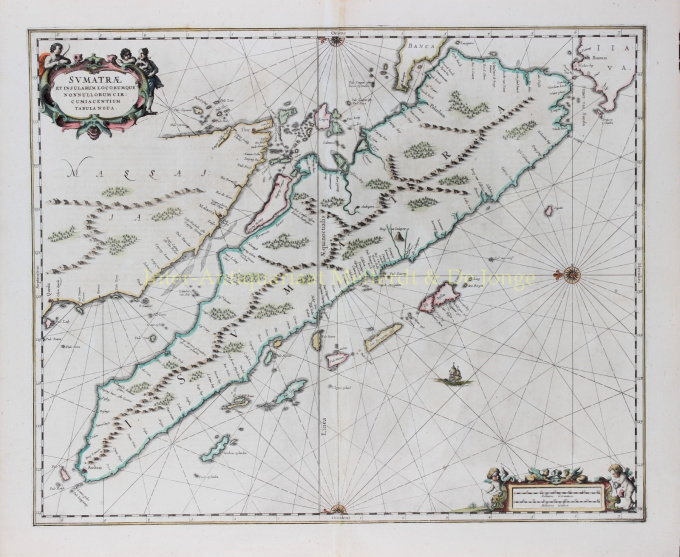
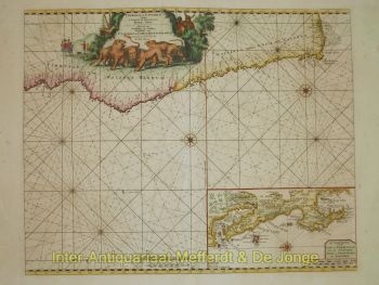
- A proposito di opere d'arteFINE CHART OF SUMATRA AND THE SOUTHERN COASTS OF MALAYSIA. “Sumatrae et Insularum Locorumque Nonnullorum Circumiacentium Tabula Nova.” Copper engraving published by Johannes Janssonius (Jan Jansson) of Amsterdam in 1657 as part of his Atlas Novus. With original hand colouring. Size: 49 x 58 cm. North is orientated to the left of the page. Singapore is probably identified just to the south of Ihor (Johor Bahru) as Senasur. As the map appeared in an atlas of sea charts, little interior detail is given but the coastlines, settlements and principal coastal features are identified. It is one of the earliest detailed depictions of Sumatra and remained the most important map of the region until well into the eighteenth century. A sailing ship and two cartouches embellish the chart: a title cartouche with three allegorical figures and a mileage scale with two surveying putti. In earlier times, Sumatra had been mistaken for the Island of Sri Lanka or Taprobana. The name Taprobana, had been applied to maps of Sumatra from the fifteenth century, after a misunderstanding by the Italian traveller Nicolo de Conti. De Conti dismissed the idea that Sri Lanka was Taprobana and so identified Sumatra as the mythical island described by geographers as Eratosthenes, Strabo, Pliny, Claudius Ptolemy and Cosmas. Price: €850,-
- A proposito di opere artista
Janssonius è nato ad Arnhem come figlio di Jan Jansz, tipografo ed editore locale. In giovane età si trasferì ad Amsterdam, l'allora centro della stampa e del commercio di carte. Nel 1612 sposò Elisabeth Hondius, figlia di Jodocus Hondius. Elisabeth morì nel 1627 e Janssonius si risposò nel 1629 con Elisabeth Carlier. Andò a lavorare per suo suocero e continuò l'attività editoriale insieme a Henricus Hondius (figlio di) dopo la sua morte. Questo è stato sviluppato in uno dei più grandi del suo tempo. C'erano filiali a Berlino, Francoforte, Ginevra, Lione e Stoccolma, tra gli altri.
Sotto la guida di Janssonius, il Mercator-Hondius Atlas fu ampliato e pubblicato come Atlas Novus. Questa edizione inizialmente monovolume si trasformò ben presto in un atlante in più volumi, integrato su richiesta con carte nautiche e/o carte celesti. C'erano pubblicazioni in olandese, francese, spagnolo e latino. Come i suoi contemporanei, anche Janssonius fece uso di lastre di rame esistenti, tra cui quelle dei libri cittadini di Braun & Hogenberg e la Description de touts les Pays Bas (Descrizione di tutti i Paesi Bassi) di Lodovico Guicciardini - (edizione Cornelis Claesz.) da 1609 Sebbene Janssonius sia stato spesso accusato di aver copiato il lavoro di Willem Blaeu, si può notare che anche le mappe di Janssonius sono apparse sul mercato prima.
Dopo la morte di Janssonius, l'azienda fu portata avanti da suo genero, Johannes (Jan) van Waesbergen, che sposò sua figlia Elisabeth Janssonius (1615-1681). Molte lastre di rame dei libri cittadini furono utilizzate (a volte leggermente modificate) da Frederik de Wit. L'edificio in piazza Dam è stato affittato a Gerard Valck; Ha anche acquistato una serie di lastre da stampa nel 1694.
Sei interessato ad acquistare questa opera d'arte?
Artwork details
Related artworks
- 1 - 4 / 4
Artista Sconosciuto
A large wall map of Asia by Nicolas de Fer 1647 - 1720
Prezzo su richiestaZebregs & Röell - Fine Art - Antiques
1 - 4 / 24- 1 - 4 / 12

